


Masyhur Irsyam
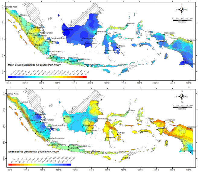
"Indonesia is a region with very high seismic activity, thus satisfactory and reliable earthquake resistant building design is required to mitigate earthquake risk. In order to conduct linear and non-linear time history analysis, National Seismic Hazard Map which gives the acceleration spectral responses does not provide adequate information as acceleration time histories inputs are needed. To be able to select and modify acceleration time histories, magnitude and source distance that represent certain location are required. Hence, rises the need for further study in the form of de-aggregation analysis, which is the determination of magnitude and source distance that represent a certain earthquake source based on total probability theorem. The result of this study is mean-source magnitude and mean-source distance map representing a certain earthquake source zone for all locations in Indonesia with earthquake return period of 1000 years and structure natural period of PGA, 0.2s, and 3.0s to accommodate bridges and retrofit for existing buildings. De-aggregation maps from this study will be proposed to be National De-aggregation Maps and to be used as reference for ground motions selection that is suitable for all location in Indonesia Indonesia is a region with very high seismic activity, thus satisfactory and reliable earthquake resistant building design is required to mitigate earthquake risk. In order to conduct linear and non-linear time history analysis, National Seismic Hazard Map which gives the acceleration spectral responses does not provide adequate information as acceleration time histories inputs are needed. To be able to select and modify acceleration time histories, magnitude and source distance that represent certain location are required. Hence, rises the need for further study in the form of de-aggregation analysis, which is the determination of magnitude and source distance that represent a certain earthquake source based on total probability theorem. The result of this study is mean-source magnitude and mean-source distance map representing a certain earthquake source zone for all locations in Indonesia with earthquake return period of 1000 years and structure natural period of PGA, 0.2s, and 3.0s to accommodate bridges and retrofit for existing buildings. De-aggregation maps from this study will be proposed to be National De-aggregation Maps and to be used as reference for ground motions selection that is suitable for all location in Indonesia"