
Heri Andreas
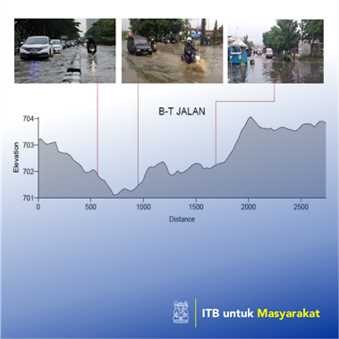
We all know that Indonesia's territory, which is roughly the same size as Eastern Europe, is full of disasters (natural, man-made, and a combination of both). Almost all potentials and disasters exist in Indonesia except those directly related to Ice. In Indonesia, ice is only found in Puncak Jaya Wijaya. The potential for disaster is small because the volumetric ice is not much and far from human existence, with the exception of climbers. In order to find out the risk of disasters in each region, efforts must be made at a detailed scale. When we talk about fire risk, for example, the scale of the details can be up to a house or building unit. When it comes to flooding, at least the flood will affect one or more villages. For this reason, at least a detailed disaster risk mapping must be made on a village scale. If we don't start, then when will the dilemma be occurred! If we start one Village at a time, we map the risk of the disaster, even though it is not significant, we try rather than stay silent. Through the P3MI ITB program, community service section, KK GEODESI try to start a detailed village-scale disaster risk mapping by taking a case study in the Gedebage area of Bandung. With limited budget, the types of potential disasters are constrained, namely looking at the correlation between flooding and land subsidence through the existence of cone subsidence and its consequences around Gedebage. The results of the mapping will be given to the Village Government to be used as material for evaluation of disaster management related to floods and land subsidence.
Penerapa Karya Seni/Desain/Arsitektur/Perencanaan Wilayah
Detailed village scale risk mapping will require enormous costs, if we look at the breadth of Indonesia. According to rough records, the number of villages in Indonesia is around 80,000 villages. If, for example, every village needs 1-2 billion rupiah for disaster risk mapping, then it can be multiplied by the amount of rupiah that must be spent (Government). It seems that there is a dilemma between disaster risk and disaster risk mapping budget, so far there has been no common ground. Although, when the disaster happened, the losses would be even greater.