
Irwan Gumilar
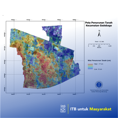
Several geodetic techniques are used in this research, i.e., the Interferometry Synthetic Aperture Radar (InSAR) and Global Navigation Satellite System (GNSS) to estimate the land subsidence rate in the Gedebage district. On the other hand, in-situ observation and web- scraping are used to assess the land subsidence’s impact on the infrastructures. Based on the results, the Gedebage district is experiencing land subsidence with a rate of up to 17 centimeters per year. The land subsidence rate tends to have a linear rate up until now. Rancabolang area in Gedebage district suffers the fastest land subsidence rate, while Cisaranten Kidul is presently the broadest area experiencing land subsidence. Several factors are causing land subsidence. However, the natural compaction, compounded due to groundwater extraction, is deemed the primary cause of land subsidence in the Gedebage district. According to the in-situ observation field survey and web-scraping activities, evidence of land subsidence in the affected area can be identified. To conclude, both InSAR and GNSS can capture the land subsidence phenomenon and complement each other, with the land subsidence rate reaching 17 cm per year. The pattern of land subsidence in the Gedebage district tends to be linear and is still happening today. Land subsidence occurs in strategic places such as sports facilities, mosques, housing estates, roads, and bridges. In these locations, many damages can interfere with the function of these objects. In the future, this land subsidence disaster must be given special attention to further infrastructure development at Gedebage district.
Penerapa Karya Seni/Desain/Arsitektur/Perencanaan Wilayah
Until now, land subsidence is still occurring in the Bandung Basin with a rate of few decimeters each year at its maximum. Gedebage district is apparently one of the districts that experienced the fastest land subsidence rate. This phenomenon should be appropriately mitigated. Otherwise, the rapid infrastructure development in Gedebage district, e.g., Gelora Bandung Lautan Api (GBLA) stadium, residential areas, Al-Jabbar Mosque, and other development activities carried out by both the local government and the private will eventually suffer from both direct and indirect impacts of land subsidence. Several impacts of land subsidence are damage to buildings, roads, bridges, and also exacerbates flooding. Hence, this research aims to map the subsidence rate and its impact in the Gedebage district with the desire that the produced map can be useful as the considerations for future development in this district.