
Alamsyah Kurniawan
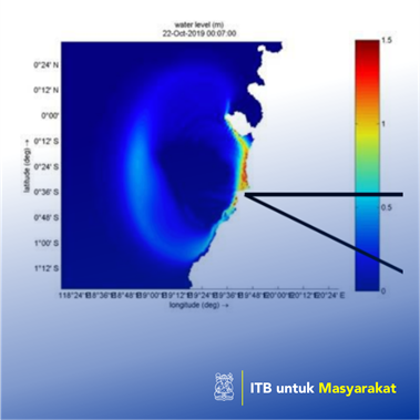
In Palu Tsunami case, some researchers conduct a post-disaster field survey and identify sites of potential subsidence along the coast. Even though disaster is inevitable, the risk could be reduced. Tsunami is considered as a rare event and unique from its generation and impact towards the affected area. From one case to another, a lesson learn could be taken to improve either disaster awareness on society or mitigation action ought to be performed. Tailoring strategies to set a countermeasure the disaster is one key for reducing its risk. Nevertheless, examining mechanisms and phenomena of disasters that occur could be an effective step – even though it is a longer project. Implementation of the Tsunami Hazard Map could be one of the key preliminary stages to raise awareness on Tsunami disaster risk reduction and spatial planning for coastal cities. A Tsunami hazard map shows Tsunami affected area both in the context of its inundation depth and coverage. It calls for reference of evacuation planning strategies and setting up a warning system. This product also an essence for spatial planning to set mitigation from Tsunami impacts. Based on 2018 Palu Tsunami experiences, deprivation of Tsunami hazard maps, evacuation system and miscarriage of warning system leads to the high loss of life. The current advanced warning system is still hardly preventing huge casualties and catastrophic loss from Palu case since Tsunami came faster than the warning itself. One of the preliminary stages for avoiding the damage is to identify uncertainties in Tsunami arrival times and potential inundated area.
Penerapan Karya Tulis
The Tsunami in Palu, located at Sulawesi Tengah Indonesia, on September 28, 2018, portrays a complex Tsunamigenic scenario where the earthquake might not be the primary cause of the Tsunami. A sinistral strike-slip plate boundary fault system like Palu-Koro rarely produce a devastating Tsunami. The motion of strike-slip faults is caused by shearing forces and have dominant horizontal deformation. It could not provide large vertical uplift on the seabed to make a sudden move for water column above it and produce a large Tsunami. The earthquake magnitude itself relatively considered as small in the context of Tsunami generation. Nonetheless, the earthquake could be a contributor for a multi-following peril – multiple submarine landslide and liquefaction in deltaic soils failure, which in this case could have a higher contribution to generate a Tsunami. One similar incident to this case is the 2010 Haiti earthquake, where research shows that even strike-slip earthquakes, can generate Tsunamis triggering aftershocks