


Widodo
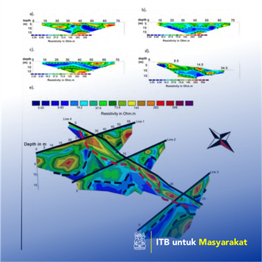
This research aims to investigate the slide plane area of landslide using a combination of two geophysical methods: Ground Penetrating Radar (GPR) and Electrical Resistivity Tomography (ERT). GPR is a non-destructive technique that is the most recommended for near-surface mapping study (Davis and Annan, 1989; Widodo, et al., 2016b; Jol, 2009; Widodo, Azimmah, and Santoso, 2018). The sensitivity of GPR data to dielectric permittivity variation could be employed for detecting any different layers in the subsurface. ERT commonly is used to define the subsurface geological structures based on resistivity variation of the rocks (Izzati et al., 2017; Bell et al., 2006; Loke and Barker, 1996). Finding the results of GPR and ERT shows the lithology of three layers. The ground movement material is composed of tuff, sand, and pebbles as soil. The potential slip of landslide is clay that can be generated from subsurface lava alteration. The third layer is interpreted as breccias lithology. Each lithology gives a resistivity value of 19.5Ωm – 74Ωm, 5Ωm – 19.5Ωm, and more than 74Ωm, respectively. The resistivity cross-section illustrates the concave shape of the slide-plane that can generate the rotational landslide in Cikahuripan Village with 20 meters in length and 15 meters in width. The geometry of landslide could be larger than the results of these geophysical surveys. This can be caused by the accessibility survey area.
Penerapan Karya Tulis
Landslides are often considered as one of the natural disasters (Fell et al., 2011) that happens frequently in Bandung due to its mountainous topography (Brahmantyo, 2005; Bell et al., 2012; Mahartha, 2017). Based on the National Disaster Management Authority of West Java (BPBD) data during January-December 2016, landslide disaster occupies the highest number of occurrences in West Java, which is 480 times or about 35 percent of the total disaster (Indrawan, 2017). Cikahuripan Village, Parongpong Subdistrict, West Bandung Regency, is chosen as the research area because it is known to have such a hilly region and accessible for data acquisition. Besides, the research area still potentially happens again. The latest movement of the Cikahuripan landslide in 2016 caused hampered transportation path due to covered by avalanches, hoarding cars, and causing casualties. Besides, high rainfall can also trigger land movement. Detection of the potential landslide zone becomes essential to pursue appropriate precautions and avoid casualties (Schuster, 1996; Varnes, 1984). EM methods are successful to investigate the geological hazards (Widodo, Tezkan, and Gurk, 2016a; Maulinadya, 2017).